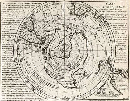
The Buache map of 1739:
http://i72.photobucket.com/albums/i181/merrypranxter/buache.jpg
Here is what an About.com article had to say:
"Buache's map of 1739 is a combination of three basic factors. European explorers and geographers had been convinced for many years that a great southern continent existed, and representations are present on many maps; it would have been unusual not to find one on Buache's. Secondly, the 1739 map illustrates a procedure that Bauche followed for much of his life - charting and understanding the first-hand reports of sailors. Finally, the map reveals the early stage of one of Buache's conclusions. In 1763 the Gentleman's Magazine, a journal famous in the 18th century, published 'Geographical and Physical Observations, including a Theory of the Antarctic Regions, and the frozen Sea which they are supposed to contain, according to the Hypothesis of the celebrated M. Buache'. In this he explained his ideas, that in order to produce huge icebergs the Southern pole must contain a frozen sea, fed by vast mountain ranges and rivers. The large central basin shown on his 1739 map is a precursor to this idea."
Let's read that second sentence again: "European explorers and geographers had been convinced for many years that a great southern continent existed, and representations are present on many maps; it would have been unusual not to find one on Buache's."
So the contention that earlier maps did not show a true Antarctica but merely a counterland are not true. Now Buache's map may not contain anything mysterious in the sense that we are using it in this thread and perhaps the Piri Reis map doesn't either but the next sentence reads:
"Secondly, the 1739 map illustrates a procedure that Bauche [sic] followed for much of his life - charting and understanding the first-hand reports of sailors."
So sailors had seen glimpses of Antarctica prior to 1819. So, then, the question remains concerning the Piri Reis map. Even if it was produced the way Buache produced his map, what sailors did the cartographer talk to and when?
|