|
|
||
Armchair Archaeologist (via Google Earth)
Related thread:
Armchair Archaeologist (via Google Earth) pt 2 (377)
|
|
|
Subject: Armchair Archaeologist From: Stilly River Sage Date: 15 Jan 18 - 01:12 PM Every so often I come across an archaeological article about some new discovery and then I travel to the location via Google Earth to look around. This one, to do with desert agriculture along the ancient Silk Road route yielded quite an interesting look at that part of China. The trick is to find the way to name the place so Google Earth can find it. "Tian Shan Mountains China" got me to the area, and then if you look at the photo in the article that gives you "Bosten Lake" you can look for the lake shape and navigate to the NW to find just the right ridges and look around and see those cisterns and fields that are clearly outlined. They stretch all down and around that small river delta. What adventures have you taken with the help of Google Earth? |
|
Subject: RE: Armchair Archaeologist (via Google Earth) From: Senoufou Date: 15 Jan 18 - 02:52 PM A few years ago, I tried to view my husband's birthplace (Adjame, Abidjan, Ivory Coast) but the pictures were spoiled by loads of thick cloud. It's a tropical/equatorial climate, so there were obviously storms obscuring the satellite photo! |
|
Subject: RE: Armchair Archaeologist (via Google Earth) From: Donuel Date: 15 Jan 18 - 06:19 PM This is fun stuff. Even kids have found unknown pyramid ruins. A different discovery.... http://www.newsweek.com/ancient-china-1000-year-old-royal-palace-summer-home-mongol-empire-liao-777972 http://www.newsweek.com/ancient-china-1000-year-old-royal-palace-summer-home-mongol-empire-liao-777972 |
|
Subject: RE: Armchair Archaeologist (via Google Earth) From: Will Fly Date: 16 Jan 18 - 04:21 AM Not having the inclination for long distance travel these days, I've looked at my cousin's house in North Island, New Zealand, and at my sister's house in Tucson, Arizona - both via Google Earth. |
|
Subject: RE: Armchair Archaeologist (via Google Earth) From: gillymor Date: 16 Jan 18 - 08:01 AM Ir's gives you a fascinating perspective of those western U.S. trout streams I've become enamored of. |
|
Subject: RE: Armchair Archaeologist (via Google Earth) From: gillymor Date: 16 Jan 18 - 08:08 AM it also enhances the reading of Himalayan mountaineering books. It gives you at least a vague sense of place that you wouldn't have without having visited a certain area. |
|
Subject: RE: Armchair Archaeologist (via Google Earth) From: gillymor Date: 16 Jan 18 - 08:26 AM ...it's also fun to follow along the trail when you're reading Western novels or American history and just about any book that's set in the outdoors. |
|
Subject: RE: Armchair Archaeologist (via Google Earth) From: Mr Red Date: 16 Jan 18 - 06:30 PM Looked fr my cousin's house in Coburg Ontario. And went looking for the house I lived in in Ngiao Gorge Wellington NZ. Not so easy, since memory is unreliable and things move on in 25 years. Saw the section (aka plot) where my neice is about to build in Napier NZ. |
|
Subject: RE: Armchair Archaeologist (via Google Earth) From: Stilly River Sage Date: 16 Jan 18 - 08:43 PM I suppose the ultimate success story of using Google Earth to track down places you remember from years ago is Lion. Here is some of the real story. |
|
Subject: RE: Armchair Archaeologist (via Google Earth) From: leeneia Date: 18 Jan 18 - 12:55 PM I sometimes use it to locate the towns named in folksongs. It's fun to discover (sometimes) that an old song is describing an actual region. It's not digital, but a great book on archeology from above is called "History from the Air." It is about the British Isles. I got it from the library and liked it so much that I bought my own copy (used.) |
|
Subject: RE: Armchair Archaeologist (via Google Earth) From: Stilly River Sage Date: 25 Jan 18 - 09:05 PM Here's another one, looking up McIntyre Promontory?s frozen slopes in the Transantarctic Mountains: Antarctica fossils story |
|
Subject: RE: Armchair Archaeologist (via Google Earth) From: Stilly River Sage Date: 27 Jan 18 - 12:13 PM I clicked on a page in a New York Times obituary for Allison Shearmur and down at the bottom of an article about her closet (whose closet has a sitting room?) is a video player that I can't break (not even viewing source code.) For the time being an article about the remote island of Saint Helena is the first in a playlist at this Elle magazine page. Scroll down to "Watch Next" to find it. Here's a BBC story about it. It's billed as the most isolated island, but it looks like Ascension Island is a contender. Both can be explored via Google Earth. |
|
Subject: RE: Armchair Archaeologist (via Google Earth) From: Vashta Nerada Date: 02 Feb 18 - 01:20 PM Sprawling Mayan network discovered under Guatemala jungle Researchers have found more than 60,000 hidden Mayan ruins in Guatemala in a major archaeological breakthrough. |
|
Subject: RE: Armchair Archaeologist (via Google Earth) From: Steve Shaw Date: 02 Feb 18 - 08:21 PM A lot of the surface evidence for archaeology in Britain is on cultivated land or in upland areas. Aerial photography has long been used to pick it out, and archaeologists choose their moment carefully. Field marks often show up best in low sunlight, especially in winter when vegetation is less overwhelming, or in droughts, or when there's been a light dusting of snow. Google Earth, for all its glories, doesn't focus in that way, though it does reveal much of interest. It's easy to find my house, which is very isolated and hard to get to, but unfortunately Google Earth's resolution is low in my area. I noticed that it's updated the images since I filled in my pond this time last year. I wonder how long it'll be before it picks up the fact that I've just spread five tons of different-coloured gravel on my drive. My back's killing me. |
|
Subject: RE: Armchair Archaeologist (via Google Earth) From: Stilly River Sage Date: 03 Feb 18 - 01:22 AM Good one, Steve. I see that Google Earth has my house fairly close and up to date, though it's still a year or two old, based on the size of the trees. The resolution is excellent for my urban area, though it shows some kind of cartoon-ish 3D features. The small raised beds in my vegetable garden are clear, as are the paths in the back yard worn down by my dogs. I was hoping to see one of the dogs in the yard, and there might be one, but not recognizable. The garden beds show the footprint before I re-tilled it 2 years ago. Also, the photo was taken before part of the patio cover came down last year, and I think before the hail storm two years ago that punched holes in the cloth over the patio cover. |
|
Subject: RE: Armchair Archaeologist (via Google Earth) From: Rusty Dobro Date: 03 Feb 18 - 03:48 AM Google Street View showed an ex of mine still living in the same house after 40 years. She was putting out the wheely bins and looking puzzled by the strange camera car going by. Ah, things could have been so different. Not better, but different... |
|
Subject: RE: Armchair Archaeologist (via Google Earth) From: Steve Shaw Date: 03 Feb 18 - 08:20 AM Just had another look at my patch. I can see the fields that have been newly-planted with Miscanthus, including one which was only done a few months ago, which still has very patchy growth. That's pretty up to date. The shadows are pointing more or less north, which means the pics were taken around midday, but the shadows are quite long, so, going from the colour of the vegetation, I'm guessing the the pics were updated in the autumn (my location is about fifty degrees north). You can sign up with Google to get them to alert you when your area has been updated. |
|
Subject: RE: Armchair Archaeologist (via Google Earth) From: Stilly River Sage Date: 03 Feb 18 - 06:18 PM Here's a group to explore in their region: The Bajau are a nomadic Malay people who have lived at sea for centuries, primarily in a tract of ocean by the Philippines, Malaysia, and Indonesia. |
|
Subject: RE: Armchair Archaeologist (via Google Earth) From: Donuel Date: 05 Feb 18 - 05:14 PM Countless Mayan city ruins discovered in Guatemala https://www.washingtonpost.com/news/speaking-of-science/wp/2018/02/03/mayan-civilization-was-much-vaster-than-known-thousands-of |
|
Subject: RE: Armchair Archaeologist (via Google Earth) From: Bill D Date: 05 Feb 18 - 05:38 PM One that I bookmarked in GE several years ago is Ggantia "Ggantija (Maltese pronunciation: [d?gan'ti?ja], "Giants' Tower") is a megalithic temple complex from the Neolithic on the Mediterranean island of Gozo. The Ggantija temples are the earliest of the Megalithic Temples of Malta. The Ggantija temples are older than the pyramids of Egypt. Their makers erected the two Ggantija temples during the Neolithic (c. 3600–2500 BCE), which makes these temples more than 5500 years old and the world's second oldest existing manmade religious structures after Göbekli Tepe. " |
|
Subject: RE: Armchair Archaeologist (via Google Earth) From: Stilly River Sage Date: 05 Feb 18 - 09:39 PM I've spent a lot of time poking around for abandoned sites that are discussed in articles like this. WHATEVER YOU DO, don't let Google convince you to switch to the new photo layer. There is very little there. Supposedly they're gradually transferring photos, but right now, you go from a view (for example) of Hirta Island, Scotland, that is dotted with photos, to a view with five iffy shots. |
|
Subject: RE: Armchair Archaeologist (via Google Earth) From: Stilly River Sage Date: 05 Feb 18 - 10:02 PM From that last article I poked around to find the Villa de Vecchi, east of Lake Como (look for Varenna on the eastern shore of Lake Como and move due east, into the river valley where you find Bindo to the NW of the house and Cortenova to the SE of the house.) There area few photos in the new layer, but there are probably tons of photos in the old Panoramio layer, with lots inside the house over the years. https://www.atlasobscura.com/places/villa-de-vecchi. |
|
Subject: RE: Armchair Archaeologist (via Google Earth) From: Stilly River Sage Date: 05 Feb 18 - 11:00 PM Here. A volcano in Iceland. Another great armchair exploration. |
|
Subject: RE: Armchair Archaeologist (via Google Earth) From: Mrrzy Date: 06 Feb 18 - 04:07 PM Senoufou, je me souviens du marche d'Adjame... on y allait moins souvent qu'a celui de Treichville. On allait au Plateau, d'habitude. |
|
Subject: RE: Armchair Archaeologist (via Google Earth) From: Donuel Date: 06 Feb 18 - 05:01 PM Ya know who started this LIDAR survey of Guatemala big time? https://news.nationalgeographic.com/2016/05/20160511-Maya-Lost-City-Canadian-Teen-Discover-Constellations-Archaeology-Satellite-Stars-Gadoury/ updated - the old link was broken - the story changed over the months. Here is more about it |
|
Subject: RE: Armchair Archaeologist (via Google Earth) From: Donuel Date: 06 Feb 18 - 06:08 PM I keep saying Guatemala but the Mayan discoveries are predominantly in the northern Yucatan Peninsula. |
|
Subject: RE: Armchair Archaeologist (via Google Earth) From: Steve Shaw Date: 06 Feb 18 - 07:03 PM Acme, we spent two days in Varenna last June. We were staying directly across the lake in Griante in a fabulous little alberghetto and we liked Varenna so much on our first visit that we went for a second day, when we climbed (in the heat!) to Castello Di Vezia, from the top of which we had glorious views, all the better as a vicious thunderstorm the night before had cleared away the customary haze. My camera went berserk. That was one of our best holidays ever. |
|
Subject: RE: Armchair Archaeologist (via Google Earth) From: Donuel Date: 06 Feb 18 - 07:59 PM Taiwan trembles from a 6.4 earthquake. Are there real time satellite images? |
|
Subject: RE: Armchair Archaeologist (via Google Earth) From: Steve Shaw Date: 06 Feb 18 - 08:16 PM That would be Vezio. Grr. |
|
Subject: RE: Armchair Archaeologist (via Google Earth) From: Stilly River Sage Date: 06 Feb 18 - 08:16 PM I've wondered if there's a way to subscribe to a closer to real-time satellite service. I'm sure the FBI, the CIA, and the Kremlin do. :) |
|
Subject: RE: Armchair Archaeologist (via Google Earth) From: Stilly River Sage Date: 27 Jul 19 - 03:09 PM Is anyone doing any interesting armchair travelling this summer? Archaeologists uncover ancient palace of the Mittani Empire in Kurdistan Region Only last year, due to a lack of rainfall and water, archeologists were able to launch a spontaneous rescue excavation of the ruins exposed by the receding water levels. One of the few helpful aspects of climate change, uncovering ancient ruins. |
|
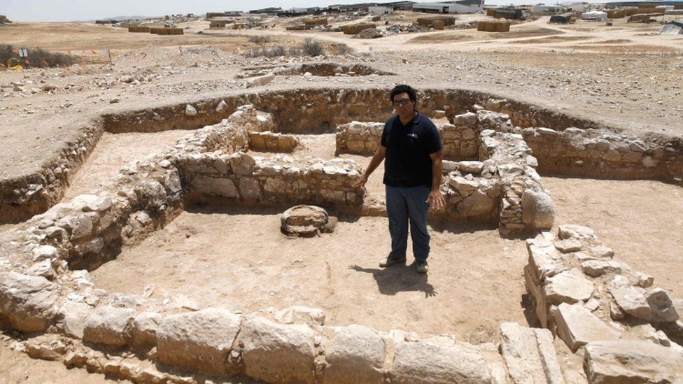
Subject: RE: Armchair Archaeologist (via Google Earth) From: Stilly River Sage Date: 28 Jul 19 - 02:20 PM https://www.thedailybeast.com/one-of-the-oldest-mosques-in-the-world-was-just-discovered-in-israel (you may have to disable your ad blockers.) Archaeologists surveying a future construction site in Rahat, Israel have unearthed something unexpected: the remains of one of the oldest mosques in the world. According to the Israel Antiquities Authority (IAA), the building was constructed around 600 or 700 A.D., when the region was mostly rural farmland. If this date is correct, this means that the newly discovered mosque was built only a few years after the death of the Prophet Muhammad in 632 A.D. I'm not sure one can fly there via Google Earth, it may not have been tagged on the map yet. If you look at the photos in the BBC article, it appears to be out on the fringes of town somewhere, and there appears to be lots of construction around the edge of town. https://www.bbc.com/news/world-middle-east-49036815 |
|
Subject: RE: Armchair Archaeologist (via Google Earth) From: Helen Date: 28 Jul 19 - 04:53 PM Not as interesting as all of your armchair travels, but when I discovered the name of the street in Wales where my Grandma was born, I Googled it and saw the row of houses where she lived. That was exciting to me. I have never travelled overseas and most likely I never will so this is the next best thing for me. When our house was newly built and for a few years afterwards if I went to street view and virtually drove past the house at the front and turned down the side street, the front view of the verandah was partially completed and the side view showed a completed verandah. A virtual TARDIS! |
|
Subject: RE: Armchair Archaeologist (via Google Earth) From: Bill D Date: 28 Jul 19 - 05:19 PM Thanks, Stilly... I'll browse those and others. |
|
Subject: RE: Armchair Archaeologist (via Google Earth) From: Mr Red Date: 30 Jul 19 - 01:07 PM Is anyone doing any interesting armchair travelling this summer? Do it all the time. To locate Village Halls, because they rarely have Post Codes and even if they do it could be the caretaker's house some distance. And because I hunt OS Bench Marks (benchmarks.mister.red) I prefer to see the terrain first - narrow roads with no footpath forewarn me of the danger of any plan. And recently I found the Milestone Society website has 12000 logs and many photos, a percentage of which reveal Bench Marks - at lest 600 in total, and I don't even have to be there! Good as the Milestone Society is, they have anomalies and it is rewarding to go GE and see where the problem is or is in my imagination. And http://what3words.com use GE - the URLs of which I publish on the Bench Mark website, so if people want to go find - I can point to within 3 metres. eg Sidmouth Anchor Gardens, where better to hold an outdoor ceilidh than at ///jumps.plus.scared or ///gladiators.bumps.games ? or a singsong at ///sing.volunteered.values |
|
Subject: RE: Armchair Archaeologist (via Google Earth) From: Helen Date: 01 Aug 19 - 04:05 PM I have started watching a TV show presented by Dr Alice Roberts: King Arthur's Britain and the initial investigation begins with an aerial view of Tintagel in Cornwall, so I am planning to do a bit of armchair investigations of my own when I have finished watching the show. |
|
Subject: RE: Armchair Archaeologist (via Google Earth) From: Bill D Date: 02 Aug 19 - 01:11 PM If you go to Rahat, Israel on GE, there is a large construction area south of the main part of the town... and one of the images> on the story page shows houses in the background. I think the discovery must be in that basic location. |
|
Subject: RE: Armchair Archaeologist (via Google Earth) From: Stilly River Sage Date: 02 Aug 19 - 02:05 PM That's what I concluded also. But with so many cul-de-sac neighborhoods marked out, you can't tell exactly which one. That reminds me - do you ever find yourself driving past a house or property and telling yourself "I'm going to look that up on Google Maps when I get home?" I often forget, doing the same exercise several times before I actually do pull up the map. Exploring my own neighborhood, in person and virtually. |
|
Subject: RE: Armchair Archaeologist (via Google Earth) From: Bill D Date: 02 Aug 19 - 09:31 PM Yes... I do that a lot. I also look up all my old addresses from the past.. only to find urban renewal has eaten up many of them. But I did find an OLD B&W pic in a family album of where my father was born in 1907 in Pitcairn, PA... with the address noted. I went to GE and LO! The house is till there and recognizable and occupied. I also find ancestors' cemeteries and look up where they are buried.... and, because the Santa Fe Trail went right by a tiny town where my father went to school, there is a site that collects old pics & info about it, and my family owned the hotel there from about 1911 to 1920 or so. About 8 years ago, I sent them some info and pics, which are included near the bottom. I now have even more to send. (and because I know where you live after the Katlaughing memorial, I browse your neighborhood also...) My GoogleEarth placemarks are around 50-60 now. |
|
Subject: RE: Armchair Archaeologist (via Google Earth) From: JennieG Date: 04 Aug 19 - 08:59 PM Interesting photos, Bill! Tell me, please - what is "Booster Day", as shown in some of those pics? I have never heard the term before. |
|
Subject: RE: Armchair Archaeologist (via Google Earth) From: Stilly River Sage Date: 04 Aug 19 - 09:49 PM A "booster" is someone who promotes the local businesses in a community for the benefit of both. It can probably be used on a larger scale, but I'm thinking in particular of a novel. If you've ever read Sinclair Lewis's Babbitt, he is a big booster in his community. |
|
Subject: RE: Armchair Archaeologist (via Google Earth) From: Bill D Date: 04 Aug 19 - 10:07 PM Yep.. like an early version of Civic Associations.... promoting the virtues and attractions of the town. I have one photo of a model T with a big sign hanging on the side saying "Good Eats at Day Hotel" I was in Lost Springs once... when I was about 10-12... for my father's HS reunion. All I really remember is that it was still small, off the main road, and had nothing for kids to do! Boosting only works when you have something to offer. |
|
Subject: RE: Armchair Archaeologist (via Google Earth) From: Stilly River Sage Date: 28 Aug 19 - 12:25 PM This travel is more time consuming and distant but is also interested in ancient history - Mars Missions Stop in Their Tracks as Red Planet Drifts to the Far Side of Sun. (Google Earth didn't participate in this one, but I think they do have a site for exploring the moon.) Through some glitch this page has the message repeated several times, the actual article is only five paragraphs). |
|
Subject: RE: Armchair Archaeologist (via Google Earth) From: Stilly River Sage Date: 31 Aug 19 - 10:09 PM Here's something interesting from Smithsonian magazine: This Map Lets You Plug in Your Address to See How It’s Changed Over the Past 750 Million Years. Interactive Map the article describes how to use it. |
|
Subject: RE: Armchair Archaeologist (via Google Earth) From: Stilly River Sage Date: 09 Sep 19 - 03:06 PM This one via YouTube, Sir David Attenborough and the Giant Dinosaur, the Titanosaur, this one found in Patagonia, Argentina. https://www.bbc.com/news/science-environment-27441156 https://www.amnh.org/exhibitions/permanent/orientation-center/the-titanosaur |
|
Subject: RE: Armchair Archaeologist (via Google Earth) From: Stilly River Sage Date: 10 Sep 19 - 03:11 PM Bones of Roman Britons provide new clues to dietary deprivation Researchers at the University of Bradford have shown a link between the diet of Roman Britons and their mortality rates for the first time, overturning a previously-held belief about the quality of the Roman diet. Using a new method of analysis, the researchers examined stable isotope data (the ratios of particular chemicals in human tissue) from the bone collagen of hundreds of Roman Britons, together with the individuals' age-of-death estimates and an established mortality model. The data sample included over 650 individuals from various published archaeological sites throughout England. The researchers—from institutions including the Museum of London, Durham University and the University of South Carolina—found that higher nitrogen isotope ratios in the bones were associated with a higher risk of mortality, while higher carbon isotope ratios were associated with a lower risk of mortality. Romano-British urban archaeological populations are characterised by higher nitrogen isotope ratios, which have been thought previously to indicate a better, or high-status, diet. But taking carbon isotope ratios, as well as death rates, into account showed that the nitrogen could also be recording long-term nutritional stress, such as deprivation or starvation. Differences in sex were also identified by the researchers, with the data showing that men typically had higher ratios of both isotopes, indicating a generally higher status diet compared to women. (The rest is at the link) |
|
Subject: RE: Armchair Archaeologist (via Google Earth) From: Stilly River Sage Date: 12 Sep 19 - 06:51 PM Hidden Japanese Settlement Found in Forests of British Columbia More than 1,000 items have been unearthed there, among them rice bowls, sake bottles and Japanese ceramics |
|
Subject: RE: Armchair Archaeologist (via Google Earth) From: Helen Date: 13 Sep 19 - 01:09 AM Is this an old enough site to be classified as "archaeology"? Probably not, but interesting: Missing man's remains found after 22 years thanks to Google Earth |
|
Subject: RE: Armchair Archaeologist (via Google Earth) From: Sandra in Sydney Date: 13 Sep 19 - 10:19 AM wow! |
|
Subject: RE: Armchair Archaeologist (via Google Earth) From: Stilly River Sage Date: 13 Sep 19 - 11:03 AM Agreed - wow! There are lots of archaeological discoveries made this way also. |
| Share Thread: |
